Auckland Council is currently undertaking a preliminary round of consultation on its proposals to give effect to Central Government intensification directives. This article updates on developments.
Introduction
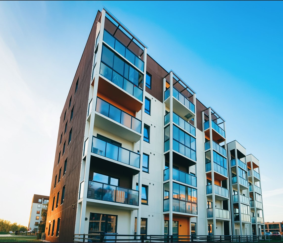
In Auckland, as in most of New Zealand, the character of neighbourhoods is shaped by the existing housing stock. For the larger part of New Zealand’s history, suburban housing has consisted of one or two story detached dwellings. Over the past few years terraced housing blocks have been built in a range of suburbs that remain mostly one to two story neighbourhoods. Our main cities have started to see five to six storey apartment buildings appear in suburban areas. However, fragmented land holdings in Auckland make it difficult to comprehensively develop already urbanised areas.
As a result of recent Central Governments directives, three story buildings will now be permitted to be built on almost all residential sites of whatever size in Auckland, Wellington, Christchurch, Hamilton, Tauranga, and Rotorua. Additionally, these tier one councils must allow “at least” six storey development nearby all city centres (there are 20 centres in Auckland) and both existing and planned rapid transit stations. There will be some exceptions to the Central Government directives, where Local Government retains discretion but at this stage, it is currently unclear which properties will qualify for an exception.
Auckland Council has requested that the public helps it to respond to the central Government directives. For anyone who wishes to engage with and assist Auckland Council, initial feedback closes on 9 May 2022. The Auckland Council will later seek submissions on formal plan changes in August 2022.
The current consultation is an opportunity to engage early with Auckland Council on these high- level issues and steer the policy direction that Auckland Council takes.
The Auckland Unitary Plan, MDRS and NPS-UD
The Auckland Unitary Plan was notified in 2014. It is now more than halfway through its ten-year life. That document enabled significant intensification in Auckland. However, given the time it takes to construct and build new dwellings the general public is perhaps only now beginning to see (and therefore be able to comprehend) the degree of change enabled by the Unitary Plan.
The Unitary Plan introduced the Mixed Housing Suburban Zone (MHS) to continue to allow for one to two storey development. It enabled three storey development in a new zone called the Mixed Housing Urban Zone (MHU). The Unitary Plan also introduced a five story Terraced Housing and Apartment (THAB) Zone near city centres and transport corridors.
Auckland Council has calculated that there are still around 900,000 potential sites that remain to be developed under the existing Unitary Plan zoning.
Notwithstanding the existing development potential under the Unitary Plan, in 2021 the Government passed amendments to the RMA to require tier one councils to enable more medium-density housing (permitting to three storeys in most residential suburbs without a resource consent). Tier one councils were also required to adopt medium density residential standards (MDRS). In essence, the effect of the MDRS in Auckland is to remove the MHS zone (one to two stories) and to replace it with the MHU zone (three stories). Further details on MDRS requirements can be found here.
In addition to the MDRS, the National Policy Statement on Urban Development 2020 (NPS-UD) required tier one councils to provide for greater density around city centres and rapid transit stations.
Auckland Council’s proposed response to the MDRS, is to zone most of Auckland’s suburban housing areas “Residential – Mixed Housing Urban Zone – Modified” (MHUM). This new zone amends MHU zone rules to meet the MDRS. Auckland Council also proposes to apply the MHUM zone to most areas that were previously Single House or MHS.
NPS-UD Requirements
Policy 3 of the NPS-UD requires:
- Building heights and density to enable as much development capacity as possible in the city centre.
- Building heights and density to reflect demand for housing and business use in metropolitan centres, and building heights of “at least” 6 storeys in all cases. (Note: the use of “at least” indicates that 5 storey development will not in the future be permitted in metropolitan centres);
- More high-density buildings of six storeys or more within walkable distances to the city centre, ten large metropolitan centres and existing and planned rapid transit stops.
- Building heights and density of urban form “commensurate” with the level of commercial activities and community services “within and adjacent to” neighbourhood centre zones, local centre zones, and town centre zones.
The adequacy of the existing infrastructure remains among the greatest constraints on development. It is yet to be seen whether the directives of the NPS-UD and the MDRS can be reconciled with the existing level of infrastructure and financial constraints on delivering new infrastructure or upgrading the capacity of existing infrastructure.
Auckland Council’s proposal for intensification around centres and rapid transit stations
Most of the Central Government directives in the MDRS and NPS-UD are mandatory.
One area Central Government gave councils discretion over was in relation to defining what a “walkable catchment” is. Walkable catchments are used to define the extent of the area around a rapid transit station or centre to be intensified.
Auckland Council has proposed that walkable catchments are determined by the distance that people actually walk, rather than the distance as the crow flies. The image below shows the difference between 800m from the edge of a Metropolitan Centre as the crow flies distance (dashed black circle) and Auckland Council’s proposed walkable catchment (red line).
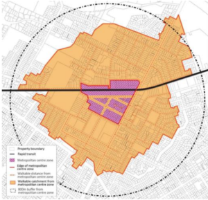
Figure One: Walkable Catchments from Auckland Council’s Consultation Materials
Council is proposing to enable more high-density buildings in the following areas:
- The Auckland city centre (enabling as much development capacity as possible).
- A 15-minute walk (1,200m) from the city centre (enabling at least six-storey development).
- Auckland’s 10 large metropolitan centres: Newmarket, Manukau, New Lynn, Sylvia Park, Botany, Papakura, Takapuna, Henderson, Albany and Westgate (enabling at least six-storey development).
- A 10-minute walk (800m) around the metropolitan centres (enabling at least six-storey development).
- A 10-minute walk (800m) around train stations and rapid busway stops – such as the stations for the Northern Busway (enabling at least six-storey development).
- A 5-minute or less walk (400m) around large town centres with high accessibility (enabling five-storey development).
- A 3-minute or less walk (200m) around small town centres or large local centres with high accessibility (enabling five-storey development).
The proposed walkable catchments have been subject to modifying factors such as topography (e.g. steep hills and physical barriers including motorways). Fundamentally important details are also still to be confirmed – for example what sized site is required for quality six storey plus apartment developments?
Effect on zoning
The below figures centred around Auckland’s Western Line show the effects on zoning of the Auckland Council’s proposed response.
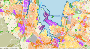
Figure Two: Operative Unitary Plan Zoning
Under the Unitary Plan (above) Dark orange is THAB (five stories). Light orange is MHU (three stories). Yellow is MHS (one to two stories). Pale-yellow is single house.
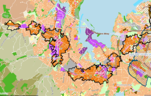
Figure Three: Proposed Zoning from Auckland Council’s Consultation Materials
Under the Auckland Council’s proposals (in response to the NPS-UD and MDRS), there are essentially just two residential zones – an enlarged band of modified THAB zoning (six storeys) around transport corridors with the rest of the Isthmus zoned MHUM (three storeys).
Under the current Unitary Plan there is more intense development near centres and transport corridors and a gradation to less intense development further away from these areas. So, the proposed changes will have a profound effect on residential zoning in the city
The Light Rail Corridor
One specific area of uncertainty relates to the light rail corridor through central Auckland. The proposed area/location of the light rail corridor is currently under investigation as shown in the below Figure.
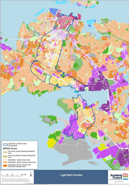
Figure Four: Light Rail Corridor from Auckland Council’s Consultation Materials
As route and station locations are not settled, where intensification of at least 6 stories, in accordance with the NPS-UD, will occur within this corridor is currently unknown.
Amenity Issues
There is a prospect that in some circumstances, six story developments may dominate, shade, and decrease the privacy of existing homes.
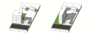
Figure Five: Comparison of six storey development forms against existing two storey development from Auckland Council’s Consultation Materials
It is not yet clear how effects on amenity (e.g., sunlight, shading and dominance) will be manged under the new framework.
Qualifying matters
Central Government has allowed some qualifying matters to reduce three-storey and six-storey building heights. This is in order to protect public open space and sites of cultural, historic, or ecological significance or to avoid development in areas with natural hazards or nationally significant infrastructure.
Auckland Council can also identify additional qualifying matters “relevant and important to Aucklanders” if it provides strong evidence to justify why it should reduce building heights and housing density in a particular area.
Auckland Council currently considers that the additional qualifying matters that are important for Aucklanders include:
- Special character areas – established areas of special architectural or other built character value.
- Ridgeline protection overlay.
- The local public views overlay.
- The Auckland War Memorial Museum viewshaft.
- The stockade hill viewshaft.
- Character buildings in City Centre Zone and Queen Street Valley precinct.
- Some of the existing built form controls in the city centre (e.g. allowing sunlight into public places).
- Areas with long-term significant infrastructure constraints (e.g. water supply, wastewater, stormwater and transport).
Where Auckland Council considers that a qualifying matter should reduce the height of buildings it is proposing to zone those areas either the Two-Storey Single Dwelling Residential Area or Two-Storey Medium Density Residential Area (depending on the nature of the qualifying matter that is being protected or recognised).
Special character areas
The effect of the proposals on existing neighbourhood character is likely to be one of the most controversial aspects of the proposal. With repeated and lengthy lockdowns and working from home, Aucklander’s have had more time than the rest of the country to contemplate what makes up their neighbourhood character. Some people will value the status quo and consider it works well for their community. Others will think intensification of their neighbourhood will benefit them.
Identifying special character areas
Auckland Council has surveyed areas subject to existing special character areas under the Unitary Plan to identify special character areas that have “high-quality” character values. Auckland Council has not assessed whether other areas meet special character requirements.
Auckland Council proposes “Special Character Area-Residential” be identified as a qualifying matter where:
- 75% or more of individual properties are considered “high quality” (i.e. score five or six out of six based on Auckland Council’s criteria) in walkable catchments; and
- 66% or more of individual properties are considered high quality outside of walkable catchments).
Auckland Council is specifically seeking feedback on special character.
How houses score a five or a six and is likely to be a matter of considerable interest. So will be the question of whether character value should be assessed independently from its location in our outside of a walkable catchment (i.e. based on its intrinsic value).
Auckland Council is evaluating special character on a “sub-area” basis, for example within a street block that contains overall high-quality special character values. The purpose of identifying sub-areas is not to retain every property that scored 5 or 6, but to identify high-value groupings. Auckland Council recognises that this will result in loss of individual properties or small groupings of high-quality special character value.
The size of the “sub-areas” is also likely to be a matter of considerable interest.
Concluding comments
While most of Central Government’s changes are mandatory, Auckland Council wants to hear from Aucklanders on the matters it does have scope to make decisions on, in particular:
- The size of the walkable catchments.
- The size of the areas around town and local centres proposed for intensification and what the building height and density limits in these areas should be.
- What “qualifying matters” may allow it to reduce building heights and density.
Although this appears limited, there will be considerable analysis and technical work behind the Auckland Council’s proposed approach. The current consultation and the August plan changes provide an opportunity for Council’s analysis and evidence to be tested. Key issues and questions to be aware of include:
- Are the proposed walkable catchments realistic?
- What sized site is required for quality six storey plus apartment developments?
- How will Auckland’s significant infrastructure constraints be managed or addressed?
- How are effects on amenity, (e.g., sunlight, shading and dominance) managed?
- Should Council seek to retain a gradation of zones and a variety of neighbourhood characters across the city and, if so, how can that be achieved in this new framework?
- Does Council’s approach to special character and other qualifying matters provide too much or too little protection?
If you or your clients need help to better understand the implications of the upcoming intensification proposals contact Joanna Beresford | Environmental Partner | 021 114 1277
Disclaimer. The information in this article is intended to provide a summary of the topic covered and is for general information only. It is provided without charge, is not comprehensive, and does not provide legal advice or other advice. Please seek independent advice before acting on any information in this article.